Baltimore Harbor: Replenishing What We've Depleted
In this story series, we explore Baltimore City's four subwatersheds. This one, Baltimore Harbor, is centrally located in the heart of downtown.
- Conservation
In this story series, we explore Baltimore City's four subwatersheds. This one, Baltimore Harbor, is centrally located in the heart of downtown.
The National Aquarium on Piers 3 and 4, jutting into Baltimore's Inner Harbor. The sandy, grassy shoreline of Dundalk's Chesterwood Park on Bullneck Creek. Fort Carroll's overgrown green hexagon rising out of the Patapsco River. The cruise ship terminal at the port near Winans Cove.
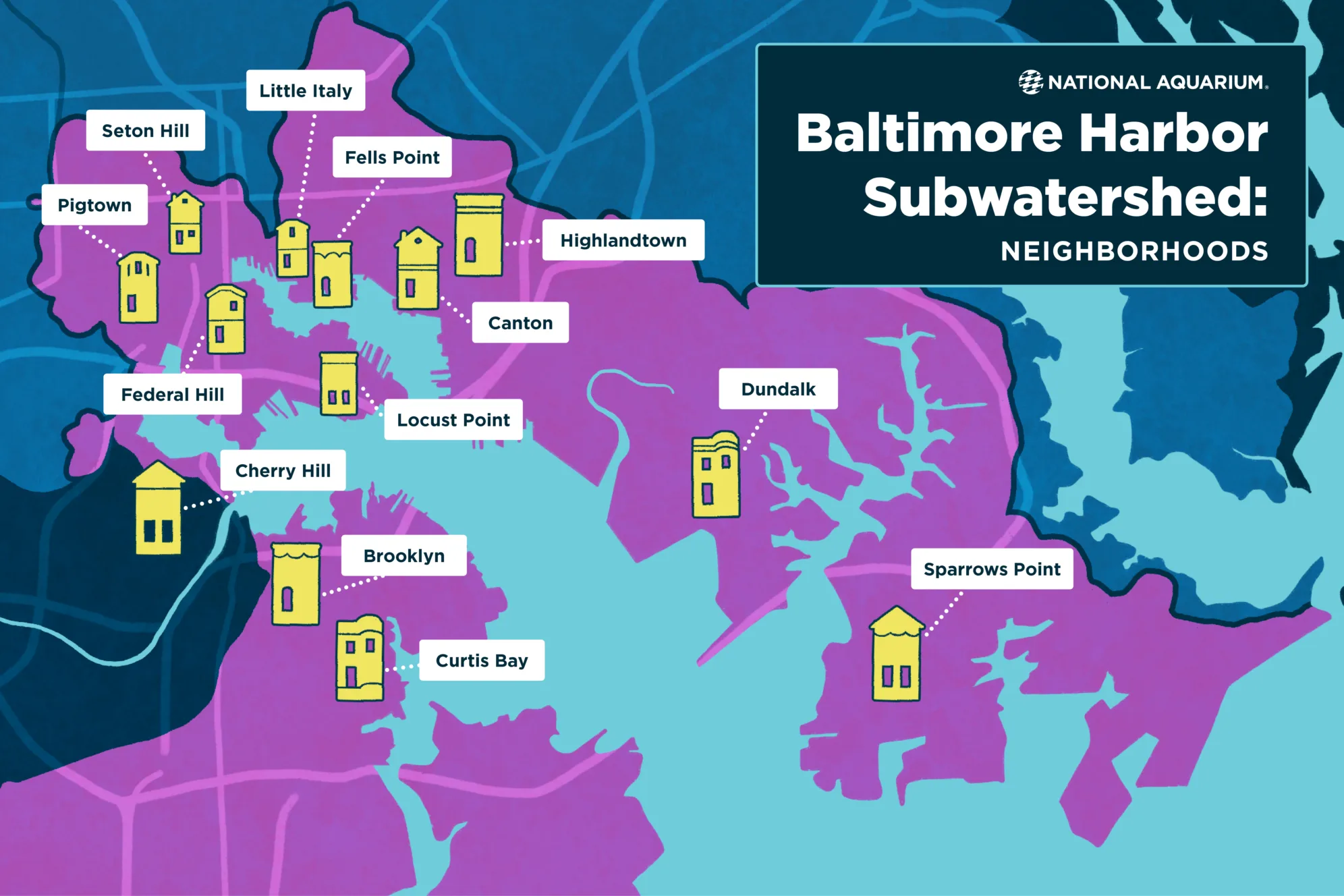
These disparate places and many, many more are found within the same subwatershed. Watersheds vary widely in size; smaller watersheds and subwatersheds are contained within larger ones.
Baltimore City as a whole is situated within the Patapsco and Back River Basin. The Patapsco River watershed is nested within the Chesapeake Bay watershed and connected to the Atlantic Ocean beyond. Within Baltimore City, there are four small subwatersheds—Baltimore Harbor, Gwynns Falls, Jones Falls and Herring Run. These are not true watersheds but are identified by hydrologic unit codes, or HUCs, by the United States Geological Survey. Together, these four areas encompass 194 square miles of land, 454 miles of streams and more than a million residents.
The Baltimore Harbor subwatershed is centrally located in the heart of downtown, horseshoeing east to west along the city's southernmost points.
Baltimore City's rivers, streams, creeks and other waterways face challenges—primarily in the form of pollution from litter, stormwater runoff, industrial sources, an aging sewage system and other issues.
Most urban waterways confront similar issues; Baltimore is not alone. Because cities are more densely populated with people, with housing, businesses and industrial sites all clustered closely together, environmental impacts to the water, land and air are more concentrated. Pollution and development also mean that urban waters typically aren't easily accessible for most people living in city neighborhoods, which can limit their ability to enjoy fishing, swimming, boating and other forms of recreation near where they live.
Baltimore's Inner Harbor was once a natural habitat of shallow mud flats fringed by tidal salt marsh grasses, surrounded by forest. It's a classic example of a shoreline that's been dredged out, paved over and built up—changed and developed in ways that inhibit the natural processes that support clean water.
Waterways, though, have always been this area's most valuable resource. The original inhabitants of the Chesapeake region include the Piscataway, Nanticoke and Susquehannock people, among many others. They harvested the plentiful fish and shellfish from local waters, grew crops in the fertile soil, and hunted game in the surrounding forests and fields. In 1730, white settlers established Baltimore Town on the north side of the Inner Basin of the Patapsco River, now the Inner Harbor. Baltimore Town's original 60 one-acre lots were located between the shallow harbor to the south, a river (the Jones Falls) and marsh on the east, a bluff and woods on the north, and large gullies on the west.
Thanks in large part to the natural resources provided by its harbor, rivers and streams, Baltimore grew quickly. Settlers built grist mills along the Jones Falls, Gwynns Falls and Patapsco, harnessing water power to run machinery that ground corn into corn meal and wheat into flour. They built long wharves lined with warehouses in the harbor to ship goods out of the city. In the 1770s, town commissioners began paving Baltimore's streets; in 1783, they put plans in place to dredge the harbor and create a shipping channel.
By the early 1800s, new mills were churning out everything from textiles and paper to lumber and gunpowder. As Baltimore grew, shipyards, brick kilns, copper and iron works, and glass factories dotted the harbor's shore. The city eventually became the world's largest manufacturer of chrome, copper and steel. Materials made in Baltimore were loaded onto ships docked in the harbor, bound for ports all around the world.
In addition to providing a power source for industry and a convenient means of transporting the goods and materials produced, Baltimore's waterways gave residents safe, reliable drinking water. The city's first municipal water system used the Jones Falls as its source; a later system relied upon the Gunpowder River. Today, the Gunpowder, North Branch of the Patapsco, and Susquehanna are the three major rivers that feed Baltimore City's water supply, which also serves Anne Arundel, Baltimore, Carroll, Harford and Howard Counties. The water system uses three reservoirs outside the city—Liberty, Loch Raven and Prettyboy—to collect and store water from the rivers, which are fed by rainfall and snowmelt.
Baltimore continued to grow after the Great Baltimore Fire of 1904 and World War I, annexing more land and standardizing the development process. National corporations—such as Western Electric, Standard Oil, and Cork Crown and Seal—built sprawling industrial parks downtown and on surrounding shores, prioritizing industry over individuals.
After World War II, Baltimore City started losing residents as more and more people moved out to the suburbs. By the late 1950s, business leaders and government officials started talking about sparking a renaissance for downtown Baltimore. Their plans included accessible public spaces, office buildings and attractions—all centered around the Inner Harbor.
One example of the impact Baltimore's industry-led growth had on the Baltimore Harbor can be found in Sparrow's Point—a stubby peninsula southeast of the city bordered by Bear Creek, the Patapsco and Old Road Bay. Developed by Pennsylvania Steel Company in 1887, Bethlehem Steel operated for more than 80 years at Sparrows Point. Its environmental impact is still felt today, a decade after the company closed its doors. On a site spanning more than 2,000 acres, Bethlehem Steel provided steady, well-paying jobs building ships and producing iron and steel. Despite these benefits, the company regularly violated pollution regulations, releasing toxic waste into the waters of Bear Creek—named for a long-gone population of black bears—the Patapsco and Old Road Bay.
In 2022, the Environmental Protection Agency added Bear Creek to the National Priorities List of sites eligible for long-term cleanup financed under the federal Superfund program. Superfund, formally known as the Comprehensive Environmental Response, Compensation and Liability Act, was established by Congress in 1980 to allow the EPA to clean up sites contaminated by manufacturing facilities, processing plants, landfills and mining sites. The EPA is currently investigating the contamination of Bear Creek and the Patapsco and exploring possible fixes.
Throughout Baltimore City, state and local entities continuously monitor water quality in the harbor and other waterways. For more than a decade, the nonprofit Blue Water Baltimore's Baltimore Harbor Waterkeeper program has measured and reported water quality data for the city's streams, rivers and harbors. The Maryland Department of Natural Resources does this as well over a wider area, through its Eyes on the Bay water quality monitoring program.
The transparency created by projects and programs like these are important for creating positive change.
"There are things we can do in cities to re-create how Mother Nature provides clean, healthy water," said Jack Cover, the National Aquarium's general curator.
Rain gardens, green roofs, urban farms, community gardens, parks, forests and other green spaces provide places where rainwater and snowmelt can accumulate and soak into the soil, which in turn filters and slowly releases clean water into nearby waterways.
"The more we can protect existing green spaces and add new green infrastructure, the better we're going to mitigate the asphalt, roads, concrete, pollution and other factors that inhibit water quality," said Jack. "This will also help reduce urban heat, increase biodiversity and benefit people's health."
Urban agriculture and composting are both important green infrastructure practices. Baltimore Compost Collective—a youth-led environmental justice nonprofit—is based at the Filbert Street Garden in South Baltimore's Curtis Bay neighborhood. Baltimore Compost Collective customers collect their compostable food scraps in a 5-gallon bucket. Once a week, youth employees pick up the scraps and transport them to the composting site at Filbert Street Garden. The organization currently serves more than 15 communities in Baltimore, offering curbside food scrap pick-up and drop-off locations in Curtis Bay, Locust Point, Federal Hill, Riverside, Mount Washington, Upper Fells Point and other neighborhoods.
Typically, more than half of the municipal garbage that's sent to landfills and incinerators is organic waste that could be composted. Landfills are major sources of methane; incinerators spew carbon dioxide and other chemicals into the air. These heat-trapping gases contribute to climate change. They also negatively impact air quality and affect human health. Air pollution is a major issue in Curtis Bay, home to a coal facility, chemical plants, a city landfill, a rendering plant, a sewage treatment plant, a medical waste incinerator, and oil and gas storage tanks.
Marvin Hayes, chief executive director of Baltimore Compost Collective, points out that incinerators tend to be built in poor neighborhoods. "A lot of people aren't aware that trash is brought here [to Baltimore City] from Howard and Baltimore Counties, New Jersey, Delaware and Pennsylvania. Would they allow Baltimore City waste to be burned in Howard County or Baltimore County? We're on a mission to train youth on small-scale composting so they can divert material from landfills and incinerators, turn it into compost—or 'black gold' soil enhancer—and in the process be inspired and empowered to be the next generation of environmental justice leaders."
Healthy soil is absolutely essential to a healthy watershed. When added to soil, organically rich compost restores depleted nutrients, increases water retention and decreases contaminants by improving the soil's ability to hold more water and filter out urban stormwater pollutants.
The new National Aquarium Harbor Wetland presented by CFG Bank is another example of green infrastructure. The Aquarium started experimenting with floating wetland technology in 2010. The goals were to reintroduce wetland habitat into the Inner Harbor to promote healthy water and attract native wildlife. After several years of studying the results and refining the design, construction of a network of these small, human-made islands is now underway. Harbor Wetland is set to open in 2024.
The Aquarium's floating wetlands mimic a natural salt marsh habitat, reintroducing the ecosystem functions that used to exist here before the area was dredged, paved and developed. The prototype floating wetland that will be replicated in Harbor Wetland allows for a variety of high and low marsh shrubs and grasses planted around a center channel featuring an aeration system that moves water, mimicking a shallow-water habitat. It is made from materials designed to withstand the harbor's brackish water and Baltimore's four seasons.
"When you're in a city, surrounded by buildings, you might think you're completely separated from nature, but you really aren't. You're never out of nature," Jack says. "Water flows through Baltimore on its way to the Bay and the ocean. It can't be bypassed. Seafood, steel—these industries were created using the city's natural resources. I think we've reached a point in our history where it's time to give back, to replenish what we've depleted."
Historical images courtesy of: Detroit Publishing Co, P. (1906) Baltimore from Federal Hill. Baltimore, Maryland, 1906. Retrieved from the Library of Congress, https://www.loc.gov/item/2015649118/.
Updated on October 8, 2024 for clarification purposes.
Stay close to home with stories and videos about Baltimore's Inner Harbor and how we care for Aquarium animals' teeth, beaks and bills—and then follow us to the literal end of the Earth, to Antarctica.
Your gift supports the highest level of animal care and advances research, education and conservation action.